Working with a diverse range of clients on CKAN-powered open data portals and data catalogues often throws up all manner of technological challenges our developers must deal with. And in the process, they often come up with innovative ways of doing things that involve new CKAN extensions or improvements to CKAN’s core software.
This blog post is co-authored by Lex Du Plessis, Technical Delivery Manager at Link Digital.
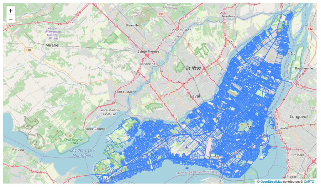
The latest of these, a new extension to enable the viewing of GeoPackages in CKAN, was developed by our Canadian subsidiary, Datashades Ltd., in the process of working on the Quebec Regional Transport Authority Data Platform. Referred to locally as the Autorité régionale de transport métropolitain, ARTM is the government transportation authority that plans, finances, and integrates public transport in Greater Montreal in Quebec, Canada.
The project, still under development, involves the establishment of a public data hub and an internal data catalogue, enhancing data management and accessibility for public visitors, authenticated data consumers, and ARTM staff.
Let’s take a very quick look at the new extension and the functionality it adds to CKAN.
Improving GeoPackage viewing in CKAN
Defined most simply, a GeoPackage is a file format that enables the design and viewing of maps with layers. This can include vector features – the representation of an object or data point as a collection of numerical values – and raster tiles – a pre-rendered image used to display maps on the internet and the connected attributes.
The maps can be accessed, visualised and analysed in Geographic Information System software designed to capture, store, manage and present all types of geospatial data, and make them viewable on desktops, websites, and mobile devices or, for the purposes of the ARTM, in an internal data catalogue or open data portal. GeoPackage files can also support advanced features like spatial indexes and metadata for efficient management and querying.
Widely used in urban planning and environmental management, GeoPackage files enable data managers to efficiently combine multiple geospatial data types into a single file. They are interoperable with other databases and web services and can easily handle large datasets.
For data users, GeoPackage files deliver a richer data experience, enabling them to undertake queries and investigate relationships between different geospatial features, giving them a better overview of the subject in question and how their question relates to a larger geographic context.
The ARTM team were looking to view GeoPackages in the portal, but CKAN’s existing functionality was limited in this regard and there was no good extension to enable this capability. It was then that we hit on the idea of using the official GeoPackage JavaScript implementation on the OGC GeoPackage to develop a new extension, ckanext-gpkg-view. This enables a simple preview for GeoPackage files in CKAN.
Improving CKAN’s dataset series extension
Delivering added functionality in relation to GeoPackages was not the only benefit for CKAN to come out of the ARTM project. Link Digital also used it to help develop and improve the CKAN Dataset series extension.
Dataset series basically relate to any group of datasets that share a common characteristic, whether it be data structure, scope, geographic domain, etc. Dataset series can be ordered or unordered. If ordered they follow a list and there is a first and last item of the series, plus next and previous datasets for individual members.
Dataset Series are well supported in CKAN. Ckanext-data-series provides a fast and lightweight underlying implementation, including the API and UI for publishers to manage a dataset’s series and its members. Ckanext-dcat provides seamless integration to expose these dataset series to other catalogs and systems in a DCAT compliant way.
Link Digital used the ARTM project, as an opportunity to make the extension more production-ready by building the missing UI bits, namely form snippets to let publishers know which series a dataset belongs to and configure the dataset series themselves, as well as a navigation UI in the dataset page of a dataset series member pointing to the previous and next datasets in the series. It means, for example, that if you are looking at the 2024 budget for something, you can easily jump to the 2023 or 2025 ones (the previous and next ones on the series).
Benefitting the whole CKAN community
The best thing about both the GeoPackage extension and the improvements to the dataset series extension that have come out of the ARTM project, is that they represent added functionality that will be available for the entire CKAN community.
As a CKAN co-steward, giving back to the community around the software is not only core business. It is something that gives us great satisfaction.
Want to build a CKAN-powered open data portal or internal data catalogue?
Contact us and one of our experts will be in touch.